You are here
Lecture held on mapping progress of Black Desert
By Saeb Rawashdeh - Oct 02,2019 - Last updated at Oct 03,2019

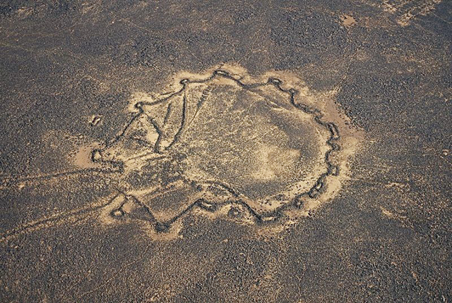
Aerial view of the Black Desert, which covers some 55,000 square kilometres (Photo courtesy of WHS)
AMMAN — The Western Harra Survey (WHS), started in 2015, has been investigating the north-east of the Azraq basin, noted a British archaeologist at a lecture titled “Back from the Black Desert” held on Tuesday at the French Institute in Jabel Luweibdeh.
That arid region is paved with basalt boulders that for centuries have been used for construction, noted Stefan Smith from the University of Gent, adding that the WHS is investigating prehistoric patterns of settlements by studying the human occupation and environment of the western edges and interior of the Black Desert (eastern Jordan).
“The desert covers 55,000 sq.km of basaltic plateau from south of Syria across the northeast of Jordan and northwest of Saudi Arabia,” Smith said, adding that in 2019 the WHS associated with Institut Français du Proche-Orient in Amman (Ifpo).
The Black Desert drew the interest of scholars back in 1920 when the first aerial surveys were conducted by Percy Maitland and L.Rees who operated between Baghdad and Cairo as airmen, Smith said.
In more recent time scholars like Gary Rollefson, Peter Akkermans, Tobias Richeter and Bernd Mueller-Neuhof run their own research in that region, he added.
“There is a long period of occupation of the region from at least the Epipaleolithic period [12,500 BC] to present day, and particularly well attested from the Late Neolithic to Early Bronze Age [circa 6,600-2,850],” Smith said.
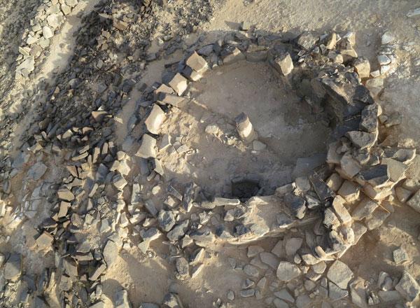
He added that a variety of sites and morphology allowed scholars to categorise them as meandering walls, kites, wheels, pendants and enclosures.
In order to survive, inhabitants of the Black Desert made hunting infrastructures in a form of thousands of “desert kites”, traps for catching animal herds, especially gazelles, Smith noted, adding that many sites are barely studied.
Using satellite imagery, researchers mapped pathways in Eastern Desert, said Marie-Laure Chambrade from the University of Lyon, noting that there are different routes: pre-modern, sheep and modern vehicle tracks.
Talking about regional ramifications Chambrade outlined extension of burin (a flint tool with a chisel point) sites, Dabba marble, shells from the Mediterranean Sea and Red Sea, ritual practices in southeast Jordan and advance of dolmens.
Chambrade said for the second phase of the WHS, the team plans to study the ancient circulation of people through the desert, map the paths, start spatial and statistical analyses, investigate territory of the desert, as well as collaborating with Jordanian colleagues.

Related Articles
AMMAN — Desert kites are human made stone structures with a convergent shape, which have lengths ranging from less than a hundred metres to
AMMAN — When a group of scholars in 2008 began to work together in the Black Desert (eastern Jordan), they found many piles of rocks that on

AMMAN — Climate change, particularly drought, created societal shifts in the Black Desert in eastern Jordan, according to a British scholar.

Opinion

Apr 18, 2024


Apr 18, 2024

- Popular
- Rated
- Commented
Apr 18, 2024
Apr 16, 2024
Apr 18, 2024


Newsletter
Get top stories and blog posts emailed to you each day.