You are here
Researchers explore development of Hajj pilgrimage routes in Jordan
By Saeb Rawashdeh - Apr 15,2019 - Last updated at Apr 18,2019
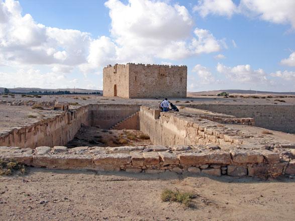
In this photo from 2014, Qala‘at Qatrana fort and water reservoirs (in the foreground), can be seen. The fort was built in 1559 by order of Sultan Suleiman the Magnificent on the Ottoman Darb al Hajj in Southern Jordan (Photo courtesy of Claudine Dauphin)
AMMAN — Before large-scale development and air travel, the Hajj pilgrimage routes comprised mostly of dirt roads, but according researchers, the routes began to flourish due to Ottoman construction works and a network of protective forts.
A researcher studying the ancient routes used for Hajj pilgrimages recently told The Jordan Times that reconstructions of pilgrims’ camps revealed a “vast” reconstructing of the natural landscape during the period.
The Umayyad and Medieval Hajj routes were dirt road, which hugged the topography and incorporated stretches of the Kings’ Road and of the Via Nova Traiana, however, the Ottoman route and its forts were artificially created, according to a French scholar.
Since 2014, Claudine Dauphin has surveyed and mapped the six Medieval and 12 Ottoman Hajj pilgrim camps used in Jordan through a project affiliated with the Council for British Research in the Levant, and funded by the Augustus Foundation and by the Palestine Exploration Fund, together with Tunisian GIS expert Mohamed Ben Jeddou and the Department of Antiquities.
The Ottoman route was cut further inland in the semi-desert, as a defence system of the Red Sea coast in Arabia (to thwart Portuguese ambitions for supremacy in the Persian Gulf and in the Red Sea), forming a strong and direct line of communication between the Hijaz, Syria, Anatolia and the Ottoman capital, noted Dauphin, who received her PhD from the University of Edinburgh.
It was partly replaced from 1910 by the much faster Hijaz Railway, a project conceived by Sultan Abdülhamid II and funded by popular subscription in the Muslim world, but hated by the local bedouins who called it “the Devil’s Donkey”, as the Sultan had stopped paying them to “protect” the caravan rather than raid it.
Moreover, the Hajj forts in Jordan formed the last defence against a possible invasion by the Western powers — from 1882 to 1914. Ships of the British royal navy controlled the eastern Mediterranean from their bases in Egypt, Dauphin elaborated, adding that the consolidation of Ottoman domination over the Sultan’s Arab subjects was linked to the control of the bedouin threat.
“The Ottoman forts of the Darb Al Hajj Al Shami constituted the first line of defence on the east against the raids of bedouin tribes — a danger which increased with drought at the end of the 17th century, pushing westwards a new influx of tribes,” she underlined.
“Besides the road itself... the building project included access roads associated with bridges over small wadis, which were particularly dangerous in winter owning to flashfloods, and which led the pilgrims to the forts,” the scholar elaborated.
From the archaeological discoveries it is possible to reconstruct the pilgrims’ camps at the stopovers on the Darb Al Hajj in Jordan, she continued, adding that the internal subdivisions of a bedouin camp were based on clans, whereas those of a Hajj camp pertained to social hierarchy and nationality.
“On a vast area, the encampment surrounded a fort. In the centre of this circle, next to the fort, the official tents hosted the Emir Al Hajj, the Kiswa, the Mahmal and the treasure,” Dauphin noted.
Moreover, within each subsection were rows of triangular white pilgrim tents and in front of each tent, a basic hearth for cooking was dug into the sand. Beyond this “core” of the camp, the tents of merchants and other purveyors of supplies for the pilgrims formed a second ring edged by a protective line — every 60 paces a military tent for the Hajj escort, foot-soldiers and riders on dromedaries, the researcher underlined.
The Hajj caravans brought with them thousands of animals, especially camels, which were parked in enormous enclosures, Dauphin said.
“Between the Mamluk and Ottoman periods, the natural landscapes along the Hajj Ottoman road were thus structured into ‘sacred landscapes’ and the stopovers moulded according to an ‘ideal camp’ model,” Dauphin underscored, emphasising that the team’s holistic approach combining field surveys, photointerpretation of British RAF air coverage, satellite imagery and historical sources, was a first in Islamic Landscape Archaeology.

Related Articles
AMMAN — As a hafiz who recited the holy Koran by heart and was part of the clergy at the court of Ottoman Sultan Mehmet IV (1642-1693), and

AMMAN — An ardent Ottoman traveller from the 17th century, Evliya Celebi, left a valuable account on the Hajj pilgrimage route and way stati
AMMAN — Despite the abundance of historical resources, the research on caravanserais in Jordan has been overlooked by scientists, according

Opinion

Apr 18, 2024


Apr 18, 2024

- Popular
- Rated
- Commented
Apr 18, 2024
Apr 18, 2024


Newsletter
Get top stories and blog posts emailed to you each day.