You are here
Tell Jalul excavations shed light on ancient water systems
By Saeb Rawashdeh - Feb 03,2018 - Last updated at Feb 03,2018
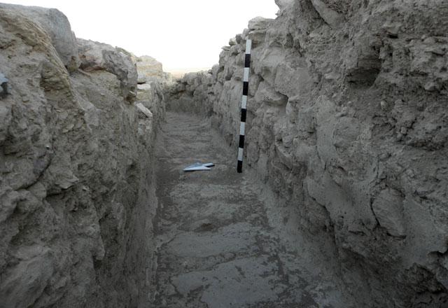
A water channel at Tell Jalul site (Photo courtesy of Paul Gregor)
AMMAN — Located in the Madaba plain, Tell Jalul is one of the largest tells (mounds) in central Jordan which was occupied from the Early Bronze Age.
Water system at Tell Jalul consists of a water channel and huge open air reservoir, said Paul Gregor, the co-director of Tell Jalul excavations.
"The reservoir was established during the 10th century BC [approximately during the reign of Solomon and/or David], while water channels were established later, during the 7th century BC," said Gregor from Andrews University, noting that, in the course of excavation, 26 years so far, researchers did not discover evidence that would indicate who occupied the site.
King Mesha of Moab claimed on his monument that Gadites lived in that region, and since the site is located in the border region it most likely changed hands between Ammonites and Moabites, the scholar continued.
"Based on biblical texts, Amorites lived in that region for some time and they were replaced by Gadites or Ruebenites. Later on, around 850 BC, King Mesha of Moab reclaimed the territory, but it is likely that Ammonites resettled in the region during the 7th century BC," Gregor elaborated.
Regarding the reservoir, which is 25 metres wide, 35 metres long and about six metres deep, it is "the largest open air reservoir built during the 10th century BC in the entire Middle East", he highlighted.
"When full, it could contain 6,000 cubic metres of water which equals to 2 million gallons," Gregor continued.
Both the floor and wall of the reservoir were plastered with lime plaster fortified with fragments of crushed flint stone, the archaeologist continued, noting that plaster on the reservoir’s floor was 30cm thick and there is evidence that it was re-plastered a few times.
According to Gregor, the location of the reservoir was carefully selected because the location most likely had a spring or water hole during the earlier periods of occupations.
"Structures of an Early Bronze settlement were found here indicating the presence of a water source and the reservoir was continuously used from the 10th to the end of the 7th century BC," he stated.
At that time, the water became abundant threatening the city of flooding. For that reason, a water channel was constructed to lead water out of the city perimetre, the researcher stressed.
"The channel is 50cm wide and its walls are up to one metre; it runs along the eastern edge of the reservoir towards and through the south eastern corner of the city wall leading the water outside the city," Gregor underlined, adding that "so far, almost 50 metres of the channel have been discovered".
During the early Persian period, he continued, the southern side of the reservoir started to leak and lose water, which prompted several attempts to separate this part of the reservoir by a huge wall built directly on the floor of the reservoir.
"It seems that the attempt failed and the wall collapsed before it was finished as there was no sign of any kind of plaster on its side," the scholar explained.
Therefore, in the early Persian period, the inhabitants dug a closed small cistern just northeast of the reservoir which still contains water nowadays.
Only around 50 per cent of the reservoir has been excavated, the scholar said, stating "we hope to unearth the entire reservoir in future excavations."
Due to the project's uniqueness and great importance, the scholar said he hopes that the government, in collaboration with the Department of Antiquities, will provide funds for its restoration and preservation so future generations can witness "this great achievement of the ancient peoples who lived in this territory".

Related Articles

AMMAN — The infrastructure of Petra, the capital of the ancient Nabateans, still remains a mystery to most people who visit this heritage si
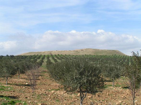
AMMAN — Tell Jalul, located 5km east of Madaba, is the largest tell( hill or mound) that covers 7.2 hectares in central Jordan, said Paul Ra

AMMAN — It is not clear whether Pella, 130km northwest of Amman, was utterly destroyed by the Hasmonean ruler Alexander Jannaeus or if it wa

Opinion

Apr 18, 2024


Apr 18, 2024

- Popular
- Rated
- Commented
Apr 18, 2024
Apr 18, 2024
Apr 16, 2024


Newsletter
Get top stories and blog posts emailed to you each day.