


 Share
Share


AMMAN — World War I marks the beginning of using aerial photography in archaeology, as cameras and airplanes improved rapidly during the war, according to a British researcher.
The pioneer of aerial archaeology, O.G.S Crawford, was an observer in an airplane on the Western Front, said Director of Endangered Archaeology of the Middle East and North Africa Robert Bewley.
“He was in charge of all the maps for northern France, so he knew the importance of linking what he saw from the air onto a map, as a record,” said Bewley, noting that when the war was finished, Crawford wrote the first basic articles on aerial archaeology, and undertook aerial photographic campaigns over southern England, culminating in the book “Wessex from the Air in 1928”.
Regarding the Middle East, the Australian Flying Corps was active in the region during the war, the scholar continued, adding that several flights of the Deutsche Luftstreitkräfte (German Air Force) undertook large-scale, well-organised aerial photographic reconnaissance over Palestine and Transjordan.
“Many of these photographs are now housed in the Bayerisches Hauptstaatsarchiv in Munich, but some prints — confiscated by Allied forces — are to be found in the collections of The National Archives, in London,” Bewley said.
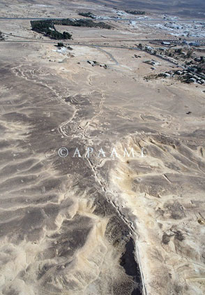
Additionally, the Aerial Archaeology in Jordan project has been photographing the trenches dug by the Ottoman and German forces to defend against the British, and these are clearly visible from the air, especially in the area around Maan, he continued.
“These photographs were taken during the retreat of the Turks through Palestine in the dying months of the fighting in the region,” Bewley said, adding that there are a minimal number of historic aerial photographs from the early 20th century of the region, including Jordan.
Aerial photography of archaeological sites also shows the urban development of the country, Bewley remarked, stressing that the rapid growth of the population in Jordan over the past 20 years, with the concomitant rise in construction (roads, dams, city and town expansions) as well as an increase in agriculture has led to a “massive and negative” impact on the archaeological sites of Jordan.
“These early aerial photographs, as well as the older satellite imagery [from the 1960s] are an important record to show the changes that have taken place, and in some cases are the only record of sites that have subsequently been destroyed,” Bewley said.
“As archaeologists, we know we can’t preserve everything, but it is important we try to record as much as possible before it is destroyed.”
