You are here
Ancient mosaic map of Madaba: Focusing on botanical details
By Saeb Rawashdeh - Feb 13,2024 - Last updated at Feb 13,2024

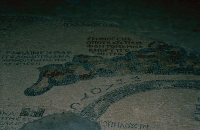
The Madaba Map with representations of palms (Photo courtesy of ACOR)
AMMAN — The sixth-century mosaic map of the Holy Land is not only an example of the Byzantine period artistry but a primary historical source about the regional geography. Towns and ecclesiastic centres of the Levant have been depicted on the Madaba Map, however, creators of the mosaic also dealt with the local flora and fauna. The representations of plants have passed unnoticed by researchers for a long time because the focus was on urban centres and famous shrines.
“Date palms [Phoenix dactylifera] are shown on the Madaba mosaic map as being grown around Scythopolis Phasaelis, Jericho, Bethagla, Bethnambris, Livias, Callirhoe and Zoara. The artist has not only shown the palm leaves schematically, but also sometimes the flower head and the orange-brown date fruit,” noted Joan Taylor from King’s College in London, adding that the western shore of the Dead Sea is largely missing and there are two other holes over the eastern coastline, but it is likely that there were other date palms indicated in the area, most especially in Engaddi.
The historian from the 1st century BC, Diodorus Siculus, wrote that in the area of the Dead Sea, “the land is good for growing palms, whether it happens to be crossed by rivers with usable water, or to be endowed with springs that can irrigate it”. Areas like Jericho were well known in ancient periods for their olives, citrons and grapes.
Jericho was called the “city of palm-trees” and there was a date palm unique to the place, “Palma caryota”, valued for its walnut-like fruit. Carbonised date pits have been found in many parts of the Herodian Palace complex in Jericho, Taylor underlined, adding that the dates of this general region were well-known for their excellent preservation qualities.
In modern times, palm trees are cultivated in areas south of the Dead Sea.
The bushes presented on the Madaba Map are of a generic plant growing around the Dead Sea and the Jordan River.
“The plant in the Jordan Valley is clearly a bush rather than a tree, since when wishing to show a tree, the artist is careful to depict a trunk [as with the palms and the terebinth]. The bushes are unlikely to be the vegetation around the river, as they are not depicted as lying immediately against the river, but are shown very boldly four times in the lower Jordan Valley.
Unfortunately, the Madaba mosaic map is not at all to scale and only approximate positions for the bushes can be given, but the impression is that they may have grown over a fairly large area in the lower Jordan Valley,” Taylor explained.
The transport over the Dead Sea is also represented by two boat bridges and they linked the area during the Roman times when the network of roads became more developed.
“There is a strikingly accurate representation of the boat bridges. These are shown as being constructed with poles at each end, with a pole in the middle going down into the river bed. Each has a small boat without oars, which would have been attached to the poles at either end by ropes,” Taylor underlined, adding that the boatman would have pulled the boat along by the ropes and by the beam across the river in order to transport goods and people.
The mosaic artist has taken special care to depict this bush in terms of its leaf and overall shape, Taylor continued, adding that it is a rather angular, low-growing shrub with deep green trifoliate leaves.
“Like the date palms, this plant must have been an important feature of the landscape, and significant economically, for it to warrant depiction by the mosaic artist. It seems, therefore, that is should be positively identified as the tree variously known as the balm of Gilead, balm of Mecca and Mecca balsam,” Taylor explained.
It is an aromatic, medium-sized evergreen tree or shrub two to five metres high, with contorted, stiff branches and numerous slender, non-spiny drooping branchlets. Its leaves are trifoliate (sometimes with five leaflets) and are present for a short time during the rainy season.
“The leaves are strongly fragrant when crushed,” Taylor said, noting that it has small white or red flowers. “The characteristics of opobalsam conform exactly to the representation of bushes in the Madaba mosaic map,” Taylor noted.
However, the plant is no longer found in the region of the lower Jordan, but may be seen in North-East Africa, Saudi Arabia and Yemen. It grows naturally among dry rocks up to circa 1200 metres on the lower slopes of the Arabian and Yemen mountains parallel to the Red Sea, Oman (Dhofar) and in the Horn of Africa.
“It was introduced into the lower Jordan Valley in ancient times, where the hot, dry conditions replicate its natural habitat,” Taylor explained.

Related Articles
AMMAN — Mosaics decorated some of most prestigious buildings in the Ummayad Caliphate: Bath houses, mosques, palaces and private villa

AMMAN — When Zeid Sinokrot started a project to cultivate date palms with his family in Jericho, a Palestinian city in the West Bank, they w
AMMAN — After winning the 2016 World Crafts City title for mosaics in 2016, Madaba has completed the first stage of “the largest mosaic piec

Opinion


- Popular
- Rated
- Commented
Jul 24, 2024


Newsletter
Get top stories and blog posts emailed to you each day.